A volcanic quarry that built Council Crest. A country house designed by Joseph Jacobberger in 1916. One of the last original homes by the man who wrote the book on Portland's classic houses. Covenants that may have expired on a single word. And a street where three layers of government look at each other and shrug. Someone started pulling at this thread. Here's what they found.
Scroll to explore
Tap colored areas for details
Chapter One
The Land
Heading north on SW 55th Avenue, past the manicured lawns of Bridlemile, the road veers west into a pocket the city forgot. The pavement narrows. The canopy thickens. After four hundred feet, it simply ends.
Two markers wait at the entrance — small things, easy to miss. They are how the story begins.
Turn the wheel left and the canopy closes overhead — Douglas fir, big-leaf maple, western red cedar — arching across a road that no longer pretends to be a road. One lane, barely. No curbs. No sidewalks. No streetlights. A century after the first carriage tracks were cut through this hillside, the woods are still trying to take it back.
A yellow diamond. A green street sign. DEAD END · SW SWEETBRIAR ST. The most ordinary signage in America, marking the entrance to one of the most peculiar tenths of a square mile in Portland.
What follows is a small story told across an immense timescale — fifteen million years of basalt, ten thousand years of glacial flood, a hundred and fifty years of survey lines, and a single county resolution from 2007 that no one outside this street has ever read. A weird little street with a weirder little history.
It didn't look like much. But when a homeowner called a land surveyor, the surveyor drove his rod into the ground, checked it against the plat, and asked a question that sounded simple:
"Where does your driveway end and the right-of-way begin?"
The homeowner didn't know. The research that followed went back more than a century.
Three feet below the surface, the sediment ends and the basalt begins. Dense, dark, fine-grained volcanic rock, under a thin layer of river-deposited mudstone and gravel.
Previous accounts called it Boring Lava. It is not. Oregon's geological survey, queried at this precise location, identifies it as Columbia River Basalt — flood basalt fifteen and a half million years old.
Fifteen million years ago this ground lay two hundred miles to the east. Eruptions in eastern Oregon sent lava flows covering areas larger than New England — traveling four hundred miles from vent to coast. A thousand feet of basalt stacked across the valley floor.
Over the eons that followed, the continent drifted west, the Cascades began their modern uplift, and the Columbia River cut downward through the rising rock. The basalt remained, buried under younger sediments in the west, exposed in the east.
Then, at the end of the last ice age, an ice dam in Montana failed. The lake held five hundred cubic miles of water. Floodwaters traveling thirty to eighty miles per hour tore down the Columbia — roughly forty times over two thousand years. Each flood submerged the Portland basin to three hundred to four hundred feet in elevation.
The Sweetbriar hillside, at roughly five hundred feet, sat just above the high-water mark. The basalt was never stripped.
Flood extent: NPS Ice Age Floods National Geologic Trail · ArcGIS FeatureServer
On the hillside above, the basalt reaches the surface. Two fault lines run through the subdivision. As basalt cools, it cracks into natural columns — five- and six-sided, separable with wedges and levers. It is the same stone in the foundations along Sweetbriar Street.
Two longtime neighbors — Grant Dean (88) and Bill Schultz (101) — both told the same story independently: the quarry was managed by two brothers, John and Gus Carlson. It provided much of the stone used to build Council Crest in the 1920s and '30s.
Gaps in the tree line, still visible in aerial photography a century later, trace the paths quarried stone was moved downhill. Bill Schultz bought the old farmhouse around 1940 for $750. No electricity. No heating. No plumbing. Water came from the creek.
The city grew around this pocket but never absorbed it. Since 1850, Portland has annexed land in every direction — 1,526 separate actions across 170 years. Drag the slider below the map and watch the city expand. The green never reaches Sweetbriar Street.
On the 1954 USGS topographic map, this hillside still appears as unimproved forest at the edge of the city. Seventy years later, the boundary still hasn't moved. The city grew around this pocket but never absorbed it. That's the oddity — visible on a map before you read a line of code.
Annexation data: City of Portland BDS/CGIS, 1,526 records. Cumulative unions computed per decade with Shapely.
Compare USGS topographic maps of this area across 110 years. The city boundary hasn't moved.
Chapter Two
The Estate
On October 26, 1915, Portland architect Joseph Jacobberger purchased "five acres more or less" from Benjamin Matthews Lombard for $4,000. Lombard was no obscure seller — he was a Naval Academy graduate (class of 1887), a Spanish-American War veteran commissioned as an ensign in 1898, and one of Portland's most active real estate developers. Lombard Street in North Portland bears his name; he platted the South Burlingame subdivision in 1910 through the Fulton Park Land Company. The property he sold to Jacobberger was part of a larger portfolio of SW Portland land holdings. Lombard died in 1920 at the age of 53.
The property sat within a grove of dense trees to the north side of Patton Road, with rural farmland to the south below the tree line. By June 1916, Jacobberger had begun designing a country home on the land. The original blueprints, titled "Jos. Jacobberger Country House," are housed in the Knight Library at the University of Oregon. The original address was simply "Johnson Road, Hillsdale." Multnomah Tax Records show improvement costs of $1,500 in 1917 and $4,000 in 1918. Geotechnical engineers hired for a 2008 foundation repair confirmed the Country House sits directly on bedrock — the same basaltic formation the Carlson brothers quarried on the hillside above.
Jacobberger died on March 18, 1930. His third wife Lovetta was added to the title according to his will; by 1932, the property had passed to the Jacobberger descendants — Hubert, Francis, Vincent, Bertram, and Margaret.
Then, in November 1945, Cecil J. Ley and Anne L. Ley bought the entire property from the Jacobberger family for $8,000. They would live on this land for sixteen years. And when they finally decided to subdivide it, they would write a set of rules for the neighborhood they were creating — rules that may still govern it, or may have quietly expired while nobody was watching.
Sources
Joseph Jacobberger: Wikipedia; NRHP #10001171 (listed Jan 24, 2011); firm "Jacobberger & Smith" confirmed via PCAD; death March 18, 1930 per Find a Grave / Oregonian obituary (which confirms "Johnson Road" address). Jacobberger architectural photographs: Oregon Historical Society, Archives West. · Benjamin M. Lombard: Naval Academy attendance and Spanish-American War service confirmed via U.S. Navy Officer Register (Cadet Midshipman Sept 21, 1881; graduated; Ensign May 24, 1898; Lt. JG Feb 11, 1899). Portland real estate activity confirmed via Friends of Columbia Park (Lombard Street named for him, 1909). Purchase price ($4,000) and death (1920, age 53) sourced from ownership timeline via county deed records. Purchase date: NRHP registration form (2010, p. 16) cites Oct 26, 1915 (Multnomah County Public Records, Room 125); neighbor-compiled timeline cites Oct 9, 1915 from the same source. NRHP date used as peer-reviewed. Knight Library blueprints confirmed via Oregon Home Magazine — original Jacobberger blueprints at UO Special Collections, used for restoration by current Country House owners. · Unverified: Ley purchase ($8,000, Nov 5, 1945); all transaction prices and dates — sourced from neighbor-compiled ownership timeline via Multnomah County Records, Room 125. Deed-book verification pending.
Sunday Oregonian · Nov 16, 1969
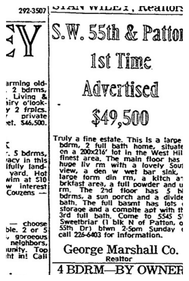
Nine weeks in the classifieds. Open houses every Sunday. No buyer. The asking price: $49,500.
1915
$4,000
Lombard → Jacobberger
1945
$8,000
Jacobberger → Ley
1969
$33,700
Ley → Marshall
Chapter Three
The Plat
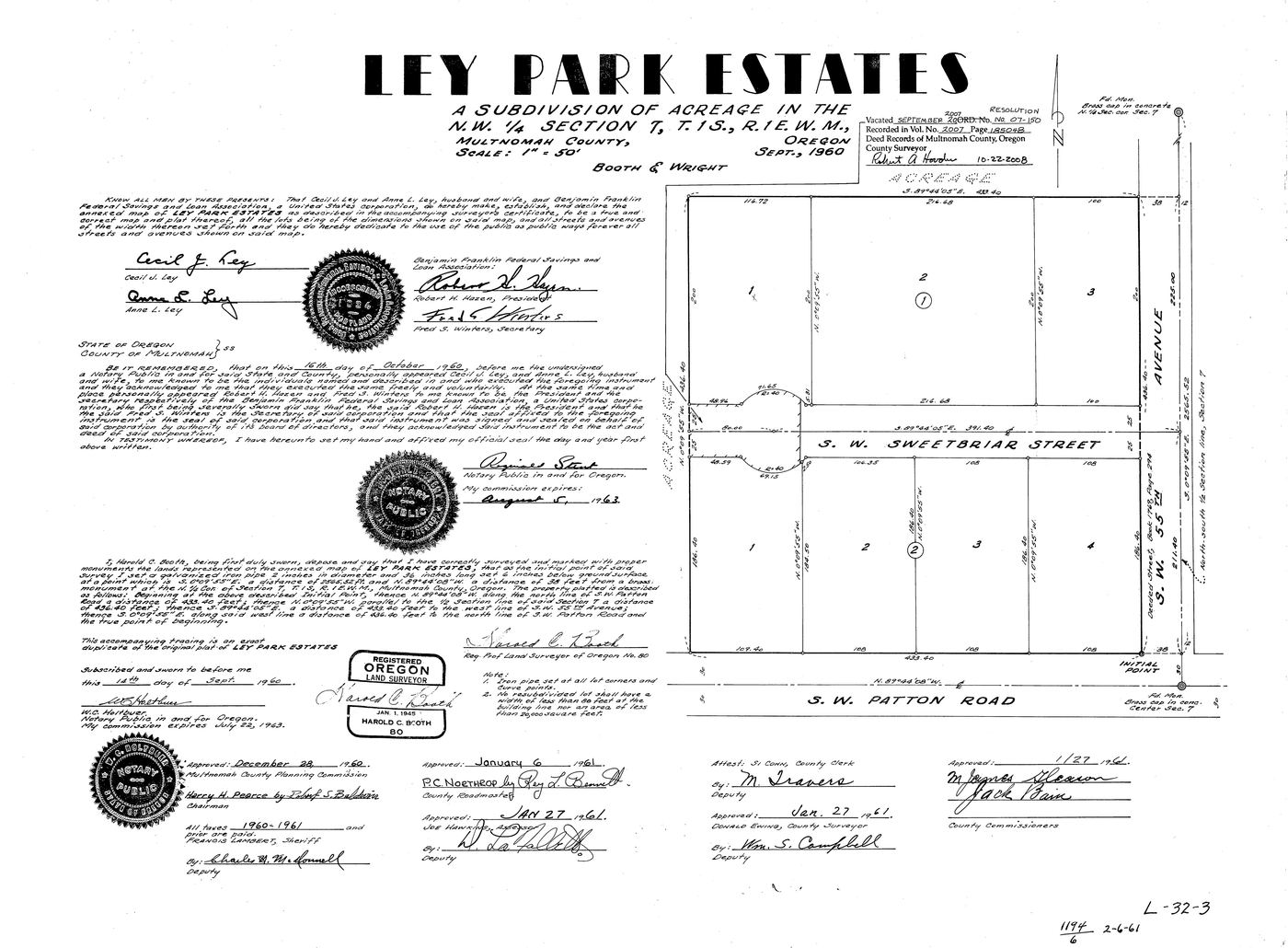
In September 1960, Booth & Wright Survey Co. surveyed the Leys' 4.5-acre property for subdivision. The result was Ley Park Estates — two blocks, seven lots, and a 50-foot public right-of-way called SW Sweetbriar Street. Block 1 ran along the north side of the road — three lots backing up to SW Woods Court. Block 2 ran along the south, with four lots fronting SW Patton Road. The Jacobberger Country House had stood on this land for 44 years before the street it sits on was formally created. The Leys kept Lot 2, Block 1 for themselves — twice the size of the other lots.
Ley Park Estates — subdivision plat Booth & Wright Survey Co. · Harold C. Roth, LS #80 · Sept 1960 Book 1194, Page 6 →
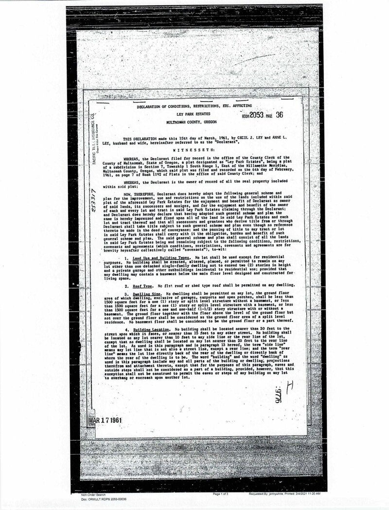
The plat was recorded on February 6, 1961. Six weeks later, on March 15, they signed a Declaration of Conditions, Restrictions, and Covenants — fourteen provisions that read like a time capsule of mid-century suburban Oregon. No flat roofs. Each home at least 1,500 square feet. No building nearer than 30 feet to the street. No tents or shacks. No horses, cows, hogs, goats, chickens, pigeons, or rabbits — though "the usual family pets" are permitted.
CC&R Declaration — page 1 of 3 Provisions 1–4: Land use, roof type, dwelling size, building setbacks Book 2053 · Page 36 · Doc 9776 · Recorded Mar 17, 1961
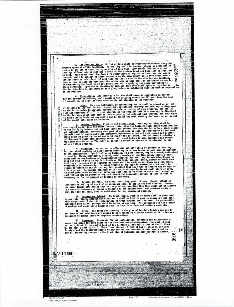
Provision 9 — titled "Nuisances" — reveals how broadly the Leys imagined their authority over the subdivision. It opens with a catch-all: nothing shall be done on any lot "which may be or may become an annoyance or nuisance to the neighborhood." Below the catch-all, it itemizes specific prohibitions: no apartments, hotels, dance halls, or manufacturing. No house trailers or commercial trucks on lots or streets except inside a garage. No grantee shall "store or park, or grant permission to store or park" anything on the street. The breadth is striking — the Leys weren't just banning specific things, they were asserting a general standard of neighborhood character and anticipating ways it might be circumvented.
CC&R Declaration — page 2 Provision 9: "Nuisances" — the catch-all that governs everything View full document →
The question of whether any of this still applies hinges on a single article. Provision 14(A) set the covenants to run until March 15, 1986, then "automatically extended for a successive period of twenty-five (25) years." Singular. If "a successive period" means one extension: expired 2011. If rolling renewals: 2036. The text is ambiguous. A search of Multnomah County deed records found no recorded termination vote or amendment.
CC&R Declaration — page 3 Provision 14(A): "a successive period of twenty-five years" — the ambiguity Signed by Cecil J. Ley and Anne L. Ley · Notarized Mar 17, 1961
By 1967, a sewer easement signed at "5545 S.W. Sweetbriar St." confirmed the Leys were still living in the Country House. By 1969, Anne Ley was a widow. The house was sold to the George Marshall Company for $33,700. On November 16, 1969, Marshall listed it in the Sunday Oregonian real estate classifieds — "S.W. 55th & Patton, 1st Time Advertised, $49,500" — and ran the ad every week for at least nine weeks, holding open houses through mid-January 1970. It did not sell. The Jacobberger Country House had survived for half a century. It was about to be torn down — until a lawyer heard about it.
Recorded Documents
Ley Park Estates plat: Book 1194, Page 6, recorded Feb 6, 1961, Multnomah County. Surveyor: Harold C. Roth, Oregon LS #80, Booth & Wright Survey Co. · CC&R Declaration: Book 2053, Page 36, Doc. 9776, recorded Mar 17, 1961. · Columbia-Wilcox sewer easement: Book 585, pp. 111–113, Sept 28, 1967. · Street name origin: under ORS 92.090 and Multnomah County plat-naming policy, subdivision names are approved by the County Surveyor; street names within a plat were chosen by the developer. "Sweetbriar" was selected by the Leys and/or Booth & Wright. The specific motive is undocumented. Sweetbriar rose (Rosa rubiginosa) is a fragrant European wild rose widely naturalized in western Oregon.
Chapter Four
The People
In February 1970, a Portland lawyer named Ron Anderson heard that the Jacobberger Country House was about to be torn down. He and his wife Patty bought it for $39,000 and saved it. They salvaged old doors from the Jackson Tower building in downtown Portland and in 1975 added the pool by dynamiting through volcanic bedrock. Ron later described it as "a loud and exciting neighborhood event."
That same year, 1975, another house went up on the street. William J. Hawkins III — the architect who would go on to author Classic Houses of Portland, Oregon, 1850–1950 and co-found the preservation movement that saved Pioneer Courthouse, The Old Church, and Officer's Row — designed 5639 SW Sweetbriar in the narrow window when he was pivoting from original design to preservation. He'd already founded the Portland Friends of Cast-Iron Architecture. His first book would come out the following year. Oregon ArtsWatch would later call him "Portland's elder statesman of architecture and historic preservation." The house at 5639, built by Leonard Hadlow, may be among the last original residential commissions Hawkins completed before dedicating himself fully to saving other people's buildings. In December 1981, it was featured in Armstrong's Good Ideas for Decorating — "A House Designed for Entertaining," written by Ellen Conry Betsch.
The Country House changed hands several times — through Gene and Carolyn Chao in 1978, who built a 3,094-square-foot garage house next door in 1986 — larger than most Portland homes, styled to evoke a historic carriage house. In 1992, Jorge and Muriel Fahey divided Lot 2 into two parcels, creating two separate residences — the Country House at 5545 and the garage house at 5609. The Murphys bought the main house in 1994 and began renovations. In 2001, the current owners acquired the Country House and have been remodeling it room by room and documenting its history. The garage house remains a separate parcel under different ownership. In 2007-08, the original stone foundation was reinforced with seismic upgrades. By the early 2000s, all seven original lots were built out, and the Patton Hills development had added three more along SW 57th Avenue — ten households sharing a road that no government would claim. Two architecturally significant homes. Sixty years of Portland design history. On a dead-end road that — as the research would reveal — no government agency claims to maintain.
1916
Joseph Jacobberger designs his Country House. Jacobberger & Smith Architects. Built on quarry bedrock.
1969
George Marshall Co. lists the Country House in the Oregonian — nine weeks. No buyer.
1970
Ron & Patty Anderson save the Country House from demolition. $39,000. Doors salvaged from Jackson Tower.
1975
William J. Hawkins III designs 5639 SW Sweetbriar. Among his last original commissions before pivoting to preservation.
Chapter Five
The Road
That was the history of the place. But this project didn't begin because of the history. It began because of the surveyor's question — where does the driveway end? — and the answer led somewhere unexpected: into the governance of the road itself.
Under ORS 368.001(3), SW Sweetbriar is classified as a Local Access Road — the most minimal road Oregon law recognizes. The county has jurisdiction but no maintenance responsibility. Three independent surveying teams — Booth & Wright (1960), Westlake Consultants (1989), and Reppeto (1993) — mapped this ROW across sixty years and achieved sub-foot closure on monuments driven into the ground in 1960. The centerline runs at latitude 45.4986136°, bearing N 89°44′05″W. The precision is extraordinary. The governance is not.
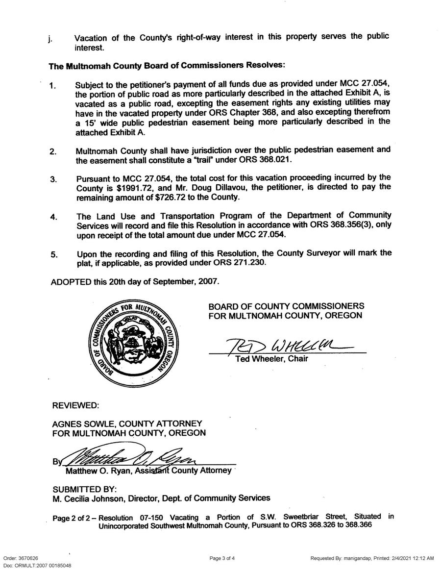
In 2007, the county proved it had jurisdiction by exercising it. Resolution No. 07-150 — signed by Ted Wheeler as Chair of the Board of County Commissioners, reviewed by the County Attorney's office under Agnes Sowle — vacated the western stub of Sweetbriar. The petitioner was Doug Dillavou, who would go on to develop the adjacent Patton Hills subdivision through Dillavou Properties LLC. Dillavou's signature later appears on both the Tract A open-space agreement and the storm sewer maintenance agreement — the same man who erased part of the road also built the shared infrastructure that replaced it.
All properties in Ley Park Estates are zoned R20 — Unincorporated Multnomah County. But they're governed by Portland's zoning code, through the West County Intergovernmental Agreement. Under the IGA, Portland voluntarily extends its regulatory arm across its own city boundary to administer zoning, building permits, and code enforcement on properties in these unincorporated pockets.
But the IGA stops at the property line. The street remains county jurisdiction. Portland's code governs what happens on your land. The county's code governs what happens on the road in front of it. And the two systems don't connect. Portland requires paved parking surfaces on properties; the county's parking code doesn't reach an unmaintained road. Regulatory frameworks exist on both sides of the property line. They just don't talk to each other across it.
If the county doesn't maintain the road, who does? The residents already knew the answer because they'd lived it. In September 2025, the neighborhood pooled approximately $30,000 and had the street repaved — a cost shared entirely by residents, with no government contribution. The paved surface — roughly 18 to 20 feet wide, estimated from aerial measurement — sits within the 50-foot platted right-of-way, leaving about 15 feet of unpaved public ROW on each side.
But the paving is just the most visible piece. The neighborhood has been maintaining its own infrastructure since the beginning. In 1967, the Leys granted Columbia-Wilcox Service District a perpetual sewer easement through Lot 1 — infrastructure carved through private land, approved by the Board of County Commissioners and the District Attorney, George Van Hoomissen — who would later serve as a justice on the Oregon Supreme Court. In 2011, two recorded maintenance agreements formalized obligations for an open-space tract and a private storm sewer system shared between Ley Park Estates and the newer Patton Hills development. The storm sewer is owned and maintained by a private homeowner, built to City of Portland standards, running through shared open space.
Meanwhile, PGE distribution poles sit inside the ROW. Water comes from Hiland Water, a private utility regulated by the Oregon PUC — not the Portland Water Bureau. Sewer and stormwater go through Clean Water Services, a Washington County special district that extends into this unincorporated pocket. Power, water, drainage — all the utilities function, served by providers from multiple jurisdictions. The infrastructure works. It's just that no public agency is responsible for the road that connects it all. So what happens when something goes wrong on a road that everyone serves and no one governs?
SourcesGeorge Van Hoomissen: Multnomah County DA 1962–1971; Oregon Supreme Court 1988–retirement. Sewer easement approval confirmed in recorded deed, Book 585, pp. 111–113. · Tract A open space agreement: Doc #2011-002118, recorded Jan 5, 2011. Storm sewer easement: Doc #2011-002122. Both signed by Doug Dillavou (Dillavou Properties LLC) and Rob Waller (Lot 1 Blk 1 owner).
The Road by the Numbers
50 ft
Platted ROW Width
~20 ft
Paved Surface
~$30K
Private Paving Cost (2025)
100%
Privately Funded
1961
Year ROW Was Dedicated
64 yrs
Without Public Maintenance
Chapter Seven
The Loop
This is where the story turns genuinely strange. Not the code gap — that's just text on paper. The strange part is what it feels like to live inside it.
Start with the address. Mail arrives addressed to Portland, Oregon 97221. Residents pay Portland property taxes. Their children attend Portland Public Schools. Portland Permitting & Development enforces zoning on the properties. But the street in front of their houses isn't Portland's street. The people on Sweetbriar live in Portland in every practical sense except the one that governs the road they drive on.
Then there are the services. Portland Fire & Rescue has responded to a false alarm at 5639 SW Sweetbriar. So has Tualatin Valley Fire & Rescue, which covers unincorporated Multnomah County. Two fire districts, one street. The Multnomah County Sheriff patrols. PGE maintains distribution poles inside the ROW. Water comes not from Portland but from Hiland Water, a private utility. Sewer and stormwater flow to Clean Water Services, a Washington County district. Every emergency service reaches this street. Every utility serves it — from different jurisdictions. Every government agency touches it in some way.
But try to get someone to enforce an ordinary regulation on the road itself — the kind of thing that happens automatically on every maintained street in Portland — and a pattern emerges. There are no speed limit signs, no fire lane markings, no streetlights, no posted restrictions of any kind. Call 311 and the city routes you to the county. The county routes you back to the city.
Confirmed, April 2026
Graham Martin, Transportation Development Manager, Multnomah County, and Kevin Cook, Principal Planner, confirmed in writing that SW Sweetbriar falls within County Transportation's jurisdiction. Primary source: personal correspondence, not publicly documented.
The pattern, once visible, repeats at every layer. The road surface? Residents pave it themselves. The storm drainage? Owned and maintained by a private homeowner under a recorded agreement. The county code that would govern conduct on the street — MCC Chapter 15 — defines "STREET or HIGHWAY" as a way that is "publicly maintained." This road isn't. The county's own nuisance control law, MCC §15.225–15.236, theoretically applies but has never been enforced here. Even the enforcement mechanism that would make the code work — posted signage — must be petitioned for and installed by the residents, at their own expense, through Multnomah County Transportation. On a maintained road, the rules apply automatically. On a local access road, the system doesn't fail to provide governance. It outsources the prerequisites for governance to the people who need it.
The contrast sharpens at the property line. Step off the street onto a property, and enforcement is robust — Portland City Code Chapter 29.70 imposes monthly fees that accrue from citation, double after three months, and become property liens. Step back onto the road, and the framework goes quiet. The enforcement machinery works on one side and doesn't reach the other. The gap is ten feet wide.
The street is governed. There's an unambiguous jurisdictional framework in Portland and Multnomah County code. But the enforcement of it is — unclear.
Who Responds? Who Enforces?
Portland Fire & Rescue
Responds to fire alarms. Has dispatched to this address.
TVFR
Covers unincorporated Multnomah County. Also responds.
Multnomah County Sheriff
Patrols. Responds to calls. MCC technically applies — but enforcement on an unmaintained LAR is discretionary at best.
Portland PP&D
Enforces zoning on the properties via IGA. Not on the street.
MultCo Code Compliance
Has jurisdiction per county staff. MCC §15.800 doesn't reach unmaintained roads.
PBOT
Not their road. Will tell you so.
311
Routes you between the above. Eventually routes you back to where you started.
Chapter Eight
The Oddity
Here is what the research turned up at the bottom of the rabbit hole.
A street built on fifteen-million-year-old flood basalt, quarried to build Council Crest. A country house designed by Joseph Jacobberger in 1916, nearly demolished, saved by a lawyer who showed up with $39,000. One of the last original residential designs by William Hawkins III — the man who literally wrote the book on Portland's classic houses — built at the exact moment he was pivoting from designing new buildings to saving old ones. Covenants from 1961 that may have expired on a single article. A road classification with no maintenance obligation. A parking code that only reaches maintained roads. A city boundary that stops short.
SW Sweetbriar St is not ungoverned because anyone chose to abandon it. It's ungoverned because multiple systems — each internally consistent — interact to produce an emergent gap. For residents, the practical effect is a kind of quiet self-governance. The neighbors maintain the road, manage the drainage, negotiate the shared space among themselves. It works most of the time, the way neighborhood life usually works — through consideration rather than code enforcement.
But there's something genuinely Portland about a place where two architecturally significant homes sit on a dead-end road that no government agency claims to maintain, where the city says "not ours" and the county says "not maintained," where the neighbors pay $30,000 to pave it themselves, and where the covenants that once governed everything might have quietly expired while nobody was watching.
There is, it turns out, a way to resolve the oddity. Under ORS 368.326, the neighborhood could petition to vacate the remaining public right-of-way entirely. Sixty percent of abutting owners, a $1,500–$3,000 filing, and the land reverts to the property owners at the centerline. The county already did this to the western stub in 2007. The logical conclusion of the research is that the only way to resolve it may be to erase the public road and govern it privately — which, in a sense, is what the residents have been doing all along.
But beneath the jurisdictional puzzle lies something more fundamental. The social contract assumes symmetry: residents surrender the right to act unilaterally — self-help is illegal, everywhere, including on unmaintained local access roads — and in exchange, the system enforces the rules on their behalf. On SW Sweetbriar, that symmetry is broken. The obligation to defer to institutional enforcement is absolute. But the institutional enforcement that justifies that obligation doesn't reach this road. The rules bind those who follow them. The gap protects those who don't.
Tap colored areas for details
Map & Geospatial Data
Parcel boundaries from the official Portland Taxlots GIS coordinate set. Road centerline from Portland GIS Street Centerlines, LOCALID 120878. Basemap: City of Portland Summer 2025 aerial orthoimagery, 6-inch resolution. Survey references digitized from the original recorded instruments at the Multnomah County Surveyor's office.
This research was conducted between 2024 and 2026 using primary sources from Multnomah County deed records (Recording Section, Room 125), the County Surveyor's office, and the Multnomah County Board of County Commissioners. Survey instruments were obtained from the original filings and digitized for GIS analysis. Naval service records were verified through the U.S. Navy Historical Command's published officer register. Architectural blueprints were confirmed at the University of Oregon's Knight Library Special Collections. Oral histories were collected independently from two longtime residents by a neighbor who documented the property's history over several years; these accounts are identified as such throughout, and corroborated where possible against the 1949 Portland House and Street Directory and county deed records. GIS boundary data uses the official Portland Taxlots and Street Centerlines coordinate sets; positional uncertainty is quantified and stated at every point where the map makes a spatial claim. Where a claim could not be verified against a primary source, it is flagged.
Geospatial Data & Cartography
Local geology overlay. DOGAMI OGDC-6 ArcGIS REST service, Group/Terrane layer (MapServer/3). Madin, I.P., 2004, Open-File Report O-04-02, 1:24,000. Queried in real-time at page load for the Sweetbriar area (bbox -122.78 to -122.69, 45.47 to 45.53). Formation polygons styled with colorblind-safe palette: blue (#2D5F8A) for Columbia River Basalt, amber (#D4920B) for Hillsboro Formation, tan (#C4A86C) for flood deposits. Boundaries at 2.5 px with dark stroke to mask simplification artifacts.
CRB province extent. Digitized by the authors from the USGS Volcano Hazards Program reference figure (public domain). Vectorization method: raster thresholding at intensity 180–240, connected-component extraction, morphological opening/closing (5×5 ellipse), contour extraction via Douglas-Peucker simplification (ε=1.5 px), affine georeferencing from 7 latitude and 8 longitude graticule ticks (RMSE: ~0.013° lon, ~0.043° lat). Full methodology and accuracy assessment in data/CRB/README.md. The resulting polygon (~251,000 km²) is suitable for regional overlays and is not a substitute for formation-level mapping from DOGAMI OGDC-7, WA DGER, or USGS SGMC.
NRHP registration form: NPS Form 10-900 (July 2010, rev. Nov 2010). Prepared by Valerie Taylor Smith with Cara Kaser (SHPO). 62 pages incl. 24 photographs. Cites: Heuer & Mercer, Hidden Brilliance: The Residential Architecture of Joseph Jacobberger (AHC, 2008); Carey, History of Oregon: Vol. 2 (1922, p. 452); Hawkins & Willingham, Classic Houses (p. 442); Knight Library Jacobberger Collection (UO Special Collections). Property purchased Oct 26, 1915 (county records, Room 125). Designed June 1916; built by 1917. Building costs $5,500 total. Lumber from West Oregon Lumber Co. (Linnton), Forest Park old-growth fir, via E.D. Kingsley.
Remaining unverified: Benjamin M. Lombard biography — needs Naval Academy alumni records and deed-book research. All transaction prices and dates prior to 2001 — sourced from neighbor-compiled ownership timeline (Multnomah County Records, Room 125); deed-book verification pending.
Unverified: 1975 commission for 5639 SW Sweetbriar, builder Leonard Hadlow — needs building-permit records. Good Ideas for Decorating, Dec/Holiday 1981, "A House Designed for Entertaining" by Ellen Conry Betsch, p. 77. Original owners Joani and Jeffrey Mattson. Magazine in current owner's possession.
Ley Park Estates plat: Book 1194, Page 6. Recorded Feb 6, 1961. Surveyor: Harold C. Roth, Oregon LS #80, Booth & Wright Survey Co.
CC&R Declaration: Book 2053, Page 36, Doc. 9776. Recorded Mar 17, 1961. Declarants: Cecil J. and Anne L. Ley.
Columbia-Wilcox sewer easement: Book 585, pp. 111–113. Board order Sept 28, 1967; deed signed July 20, 1967. Approved by George Van Hoomissen, District Attorney.
Partition Survey #51541: Westlake Consultants Inc. Surveyor: Leonard Schelsky, LS-1841. Dated Dec 6, 1989. Filed Dec 29, 1989.
PLA Survey #53736: John G. Reppeto, LS-657. Dated June 14, 1993. Filed Aug 23, 1993. For: Jorge Fahey.
George Marshall Company listing, "S.W. 55th & Patton," $49,500: Sunday Oregonian real estate classifieds, Nov 16, 1969 through at least Jan 18, 1970 (9 consecutive weeks). First ad: Nov 16, 1969, p. 125 ("1st Time Advertised"). Sourced from NewsBank / The Historical Oregonian, 1861–1987. Issues archived in project docs/.
Oral Histories & Unverified Claims
Grant Dean (88) and Bill Schultz (101): quarry operations on the hillside northeast of the property, Carlson brothers — John (owned extensive property directly northeast of Jacobberger's, ran business from off SW Hewett) and Gus (lived in the farmhouse on the lower portion). Council Crest stone supply, 1920s–30s. Bill Schultz farmhouse ($750, ~1940, no electricity/heating/plumbing). 1949 House and Street Directory confirms Schultz (5409) and John Carlson (5455) as neighbors. Quarry oral histories independently corroborated by NRHP registration form (NPS Form 10-900, 2010, pp. 16–17, footnotes 64–68), which cites the same informants and county records. Ron Anderson: house rescue, Jackson Tower doors, dynamite pool 1975. Anderson rescue and door salvage corroborated by NRHP (p. 7, footnote 10: "The door from the Journal Building was salvaged by a prior owner during the 1970 remodel of Jackson Tower").
Graham Martin and Kevin Cook (Multnomah County): April 2026 jurisdictional confirmation. Primary source: personal correspondence.